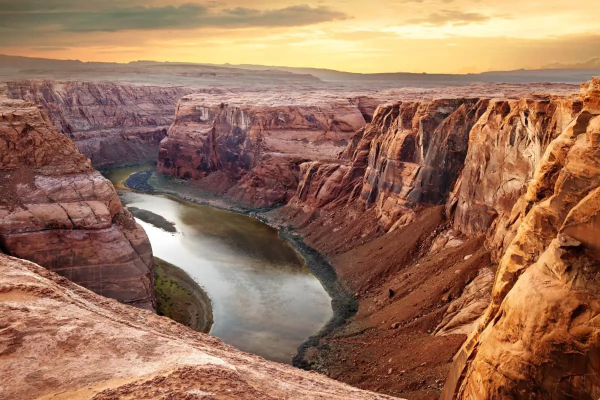
With plenty of outdoor activities to take advantage of, Arizona is a state full of some incredibly cool natural landscapes and rock formations. One of the main challenges with doing outdoor activities in Arizona is handling the heat in the warmer parts of the year. Heading to the large network of caves in Arizona can be a great year-round adventure!
30 Locations To Check Out When Caving in Arizona:
| Cave Name | Coordinates |
|---|---|
| Colossal Cave | 32.0621° N, 110.6335° W |
| Peppersauce Cave | 32.5243° N, 110.7074° W |
| Kartchner Caverns | 31.8366° N, 110.3489° W |
| Grand Canyon Caverns | 35.5180° N, 113.2192° W |
| Coronado Cave – more strenuous | 31.2140° N, 110.1538° W |
| Lava River Cave | 35.3424° N, 111.8363° W |
| Cave of the Domes – Grand Canyon | 36.0120° N, 111.5854° W |
| Cave of the Bells | 31.7230° N, 110.8409° W |
| Ice Cave Trail | 33.9106° N, 109.5851° W |
| Onyx Cave | 31.4330° N, 110.4690° W |
| The Cave on Cave Creek | 33.5002° N, 111.5748° W |
| Tapeats Cave | 36.3705° N, 112.4694° W |
| Bat Cave | 36.0426° N, 111.8251° W |
| Betatakin Cave | 36.0426° N, 113.8015° W |
| BlackJack Cave | 33.0415° N, 109.1079° W |
| Geronimo’s Cave | 33.3975° N, 111.3478° W |
| Massacre Cave | 36.1336° N, 109.4694° W |
| Mummy Cave | 44.2738° N, 109.4496° W |
| Redwall Cavern | 36.2135° N, 112.0581° W |
| Old Caves Crater Trail | 35.1613° N, 111.3208° W |
| Stanton’s (Hislop) Cave | 36.8674° N, 111.5951° W |
| Sedona Caves | 34.5446° N, 111.5010° W |
| Toppy’s Cave | 33.0209° N, 109.9311° W |
| Ventana Cave | 32.2100° N, 112.1400° W |
| Tombstone Silver Mine | 31.4249° N, 110.3599° W |
| Wave Cave Trail | 33.2142° N, 111.2760° W |
| Fay Canyon Trail | 34.5410° N, 111.5146° W |
| Wind Cave Trail | 41.7622° N, 111.7037° W |
| Robber’s Roost Cave Trail | 34.9275° N, 111.9954° W |
| Broadway Cave | 32.2208° N, 110.7262° W |
With a wide range of caves to explore across the state (over 1,000 caves!), we’ve pulled together some of the coolest caves that are open for you to visit in Arizona and their locations. If you’re thinking about a trip to Arizona, don’t miss these caving destinations.
If you’re interested in caving, be sure to read my Beginners Guide and recommended gear section.
Caving in Arizona
Spelunking, or the exploration of caves, is a popular activity in Arizona because of the vast number of caves that exist in the state. These caves range in size, natural construction, and appearance.
1. Colossal Cave
The Colossal Cave offers miles of underground area to explore. They offer three different tours ranging in length and difficulty, all giving you unique cave experiences to learn about these geological formations. This is one of the most impressive and popular guided tour caves in all of Arizona.
The Classic Tour gives a great intro to the cave’s history and geology with views of the unique development. The Ladder Tour allows you to climb through narrow passageways to see the cave from a unique perspective. The Wild Cave Tour is the most strenuous, and you’ll be able to get down and dirty to see parts of the caves that little do. Check out the tour options here.
Where to find it: Located 15 minutes outside of Tucson in Vail, check out this map with written directions. (Map coordinates: 32.0621° N, 110.6335° W)
2. Peppersauce Cave
Situated in Coronado National Forest, the Peppersauce Cave is a network of caves that spans over a mile long. Unlike some of the other popular caves in Arizona, it requires you to get a bit dirty and is not as easy to get to. After making your way up the narrow pathway to the cave, you’ll have to make your way in the tiny entrance.
Once you make your way through the initial entrance, it opens up, and there’s even a small lake inside. You’ll need to bring a flashlight as it is incredibly dark, but this is another undeveloped cave that doesn’t see the crowds like the others.
Where to find it: Located near Oracle (Tucson area), the cave is a well-known but infrequently traveled destination. You can check it out on the map here. (Map coordinates: 32.5243° N, 110.7074° W)
3. Kartchner Caverns
If there’s one cave you can’t miss while visiting Arizona, it’s the Kartchner Caverns. The formations in the cave are continuously growing and have been thousands of years. Run by the Arizona State Parks and ranked as one of the best caves to visit in the country, you can embark on tours that are led by guides nearly year-round (excluding bat breeding in the summer).
The cave stays cool, around 70 degrees Fahrenheit throughout the year, but gets extremely humid! You may need to make reservations in advance, depending on the time of year. This is one of the most popular attractions in Arizona, so it can get crowded!
Where to find it: The caves are located in Benson, Arizona, which you’ll found southeast of Tucson. (Map coordinates: 31.8366° N, 110.3489° W)
4. Grand Canyon Caverns
Grand Canyon Caverns is famous for being the largest dry cave in the country and has been developed to make viewing the cave very fun and simple. They offer a range of tours that vary in length and the number of caves you can see. The longer tours offer excursions into new caves and their growing formations. You can check out the tours here.
These caves are great for all age groups and ability levels. Equipped with an elevator, everyone can enjoy this massive cave. Plus, there are handrails and benches throughout for enhanced accessibility. You should make reservations in advance for the tours as spots can fill up quickly.
Where to find it: You can easily access the caves off of Route 66 in Seligman, Arizona. Add these caves to your list if you’re making your way across the state! (Map coordinates: 35.5180° N, 113.2192° W)
5. Coronado Cave
This is one of the more strenuous hikes for the larger caves in Arizona due to some rocks you’ll have to make your way over. It is only a mile hike round-trip, making it manageable and a fun little excursion near the Coronado National Memorial Visitor Center. It is entirely free to visit and open to the public during daylight hours.
The cave is managed by the National Park Service and can be enjoyed year-round. It is very dark inside the cave, so we recommend bringing a flashlight as you’ll be making your way over uneven rocks. You should also bring gloves as to not inhibit the growth of rocks in touching.
Where to find it: Make your way about a ¼ of a mile past the Visitor Center to find the Coronado Cave in Hereford, Arizona. (Map coordinates: 31°21′4″N 110°15′38″W)
6. Lava River Cave
As its name suggests, the cave was formed by the flow of lava! This created a long tube of a cave near a formerly active volcano over 700,000 years ago. The cave is around ¾ of a mile long, and you can see the remnants of the lava working its way through the rock, leaving newly formed rock patterns.
Lava River Cave is open year-round, but the roads to the cave may be closed in some of the winter months due to snow. It is best to visit it in the summertime as the cave maintains cool temperatures year-round. We recommend bringing a jacket even in the heat of summer as you can even see ice down there at this time of the year.
Where to find it: The cave is located near Flagstaff and can be found by navigating to this address. (Map coordinates: 35.3424° N, 111.8363° W)
7. Cave of the Domes
Cave of the Domes is a publicly open cave that requires a strenuous hike because it will take a couple of hours to reach the entrance. You will be required to have a permit to enter the cave. This can be obtained through the National Park Service.
We recommend this cave for avid hikers who want to spend a full day exploring. The cave is massive, with interesting formations found throughout. While it does take more steps to get the permit and make your way there, it’s a unique excursion.
Where to find it: Start at the Grandview Trail, and the location of the cave opening is here in Grand Canyon National Park on Horseshoe Mesa. (Map coordinates: N36 01.204′, W111 58.544′)
8. Cave of the Bells
The Cave of the Bells is a unique cave experience because it is not open to the public but can be easily accessed (if availability permits) through the Tucson Forest Supervisor’s Office. This is an attempt at conserving the area to prevent degradation. This is a great opportunity to explore an ever-growing cave.
You can put down a $100 deposit to gain access to the gate keys. You should make reservations in advance. It’s an impressively large and developed cave that has been well-maintained by visitors and the efforts of government agencies.
Where to find it: This cave is located south of Tucson in the Coronado National Forest. (Map coordinates: 31.7230° N, 110.8409° W)
9. Ice Cave Trail
While you may not find ice throughout the entire year, this cave has been formed by lava. Situated in the White Mountains, this is a leisurely hike with the small cave found along the way. Unlike many of your other Arizona hikes and caves, this one finds itself around a stream with plenty of wooded wildlife.
The cave area is fenced for conservation but is sometimes open as you pass by. This is not only for the protection of the park but for the safety of visitors.
Where to find it: Head to the Timber Mesa Trailhead. There are plenty of connecting trails if you want to maximize your hiking time. (Map coordinates of the White Mountains: 33.9106° N, 109.5851° W)
10. Onyx Cave
The Onyx Cave features fossilized sea creatures in limestone that broke and reformed throughout history to form the different rooms of the cave. This is a challenging cave to make your way through, being best for experienced hikers and cave explorers.
In order to uphold safety and maintain the cave, it is managed by Escrabrosa Inc. You can check out their website for details on how to obtain a permit as well as reserving keys to visit the cave. This is another incredible cave experience that has been well-preserved and untouched by many Arizona visitors.
Where to find it: In the Santa Rita Mountains, check out how to get to the Onyx Cave here. (Map coordinates: 31°43′3″N, 110°46′9″W)
11. The Cave on Cave Creek
This cave has a rich history as a Native American dwelling, battleground, mining home, Prohibition production site, and a place for camps and services throughout the years. In 1996, the cave was closed off from the public in order to ensure the preservation of the area. The good news is they offered guided hikes 6 times per year!
If you are interested in taking their hikes during the year (which highlight the local wildlife and vegetation) to the cave, you should sign up for the Desert Foothills Land Trust email list.
Where to find it: Located near Cave Creek, check out the location here. (Map coordinates: 33° 50′ 0.0240” N, 111° 57′ 4.8780” W)
12. Tapeats Cave
Offering a bit of a hike (and maybe a swim) up the Tapeats Creek, you’ll reach caves that contain both waters to feed the creek and fall on faults that have helped them form and reform over time. The nearby Tapeats Spring provides a significant amount of water to the region, north of the Grand Canyon.
Making your way east of the springs, you can make your way into the cave, which contains around a mile of passageways to explore.
Where to find it: Located in Grand Canyon National Park, start from the Tapeats Creek and head east for access. These step by step directions can guide you there! (Map coordinates: 36.3705°N, 112.4694°W)
13. Phoenix Bat Cave
Unlike most of the natural caves on our list, you can head to a manmade tunnel that has become home to thousands of bats in Phoenix. These bats will fly out of the cave between May and October to head to Mexico for the winter. They will leave their ‘cave’ as dusk approaches.
Watching the bats fly through the sky, especially in a populated area, is a pretty awesome way to experience nature without leaving the city. It’s a short walk to find a tunnel that has gone largely undiscovered by the masses.
Where to find it: You can park nearby this location (in a neighborhood or nearby office parking lots) and take a short walk to the ‘cave.’ (Map coordinates: 36.0426°N, 111.8251°W)
14. Betatakin Cave
Formerly a dwelling for Navajo people, the cave features ruins of old rooms and buildings within a cave in the Navajo National Monument. This is another look into the history of people who once lived in the cave. The cave covers the abandoned settlement, serving as protection at one time. This is one of the few caves that actually has remains of lives once lived!
Tours are guided by National Park Service and do not run year-round. Check their website for updates.
Where to find it: The cave is located north of Phoenix, check it out on a map here. (Map coordinates: 36.0426 °N, 113.8015°W)
15. Black Jack Cave
Named for a local criminal who was hiding out in the cave, this hike is under 2 miles roundtrip to check out the large alcove style Black Jack Cave. Hikers come to explore this cave for its history and hillside views near the New Mexico border.
Where to find it: Start at the Black Jack Campground and make your way to the cave by heading up Black Jack Canyon. Here you’ll find the exact location of the cave as you make your way up the trails. (Map coordinates: 33.04158 N, 109.10792 W)
16. Geronimo’s Cave
This 4.8-mile hike is located in the Superstition Mountains east of Phoenix, providing you with more great views of nearby landscapes and an open-faced cave. This one is cool because it offers particularly interesting photo opportunities of hoodoos (spired rock formations) and cool angles for sunset shots.
Where to find it: Start from Peralta’s Trailhead and follow your way up to the cave. For more specific directions that give you coordinates at every step, check this out. (Map coordinates of Peralta’s Trailhead: 33.3975° N, 111.3478° W)
17. Massacre Cave
Massacre Cave may not feature the grandeur of some of the other caves on our list, but it holds important history. The conflict between the Spanish and Navajo came to a head here in the 1800s when Navajo women and children were killed.
To access the cave and most of the canyon, you will need to schedule a tour with a Navajo guide or other tour companies. This is a list of authorized tour companies that can take you through the monument. These vary in tour type, and you can find one that best suits your preferences.
Where to find it: Located in the Canyon de Chelly, here is the location on the map. (Map coordinates of Canyon de Chelly: 36.1336° N, 109.4694° W)
18. Mummy Cave
The Mummy Cave is another natural feature that can only be accessed with a guide as it falls on Navajo land. This cave is very close to Massacre Cave, and both can be seen from an overlook. You can see it from the overlook on your own, but if you want to get much closer, you should refer to the approved tour list. (Map coordinates: 44°27′38.448″N 109°44′9.6″W)
Unlike many of the other caves on the list, the ones in the Canyon de Chelly offer a piece of history along with their rock formations. You can not only take in the views but learn more about the people who inhabit and have inhabited this region.
Where to find it: From the overlook, you can get a great landscape view of the cave. (Map coordinates: 44°27′38.448″N 109°44′9.6″W)
19. Redwall Cavern
The cave is only accessible by boat, so we recommend it as a great kayak or rafting journey. You’ll see a huge shaded shoreline covered by a limestone overhang, making it a fun place to hang out and enjoy the massive rocks.
The walls of the Redwall Cavern reveal their history, showing fossilized wildlife that lived in the area over thousands of years. This is also a great area for rock climbing or bouldering, but you will need to do so at your own risk.
Where to find it: Located at the North Rim of Grand Canyon National Park, you’ll find it at river Mile 33. (Map coordinates of North Rim: 36.2135° N, 112.0581° W)
20. Old Caves Crater Trail
This 4-mile hike in the Coconino National Forest takes you to the base of a volcano that has formed a crater and takes you through fields of volcanic cinder. You’ll loop around the crater and make your way through caved pathways with fun turns. The Old Caves Crater Trail is a moderate hike that should take around 2-3 hours.
Where to find it: The trail and ‘cave’ are located near Flagstaff. Check it out here. (Map coordinates of Coconino National Forest: 35°16’13.1″N 111°32’08.9″W)
21. Stanton’s (Hislop) Cave
Railroad pioneer Robert Brewster Stanton wanted to build a railway through the Grand Canyon and created a road for easy access. Today, you can take this road down to a small river (which you will need to cross with a small raft or kayak) and then follow the horse trail to what will be Hislop Cave. This will have “Hislop 1889” carved into it.
You can follow the path of switchbacks into the overhanging cave and enjoy the views of rock formations and the river that runs through the area. This hike is definitely for the more adventurous as it requires a bit of paddling and hiking. It isn’t too long of a trek, coming in at around 6 and ½ miles roundtrip.
Where to find it: Near the border of Utah in Marble Canyon, we recommend starting from Lees Ferry and making your way across the river to your final destination. (Map coordinates of Lees Ferry: 36.8674876°N, -111.5951607°W)
22. Sedona Caves
About a half a mile from the dirt lot you park in outside of Sedona, you’ll be taken through some rocky terrain to find the cave (make sure you are wearing good shoes). Once you hit the caves, complete with many twists and interesting turns, you can keep heading in!
If you make it through all the caves (which go on for a while), you’ll hit a small creek where you can relax! This hike is short but can be rocky and steep, so it isn’t recommended for small children. Make sure you dress comfortably as there will be some climbing involved. Overall, it’s a fun little hike with some great views and isn’t too crowded!
Where to find it: You can check out the map and trail directions here! (Map coordinates: 34°54’46.9″N 111°50’10.0″W)
23. Toppy’s Cave
If you are looking for a secluded adventure, you should check out Toppy’s Cave near Turtle Mountain. Closer to the Gila National Forest and New Mexico, the cave runs near Bonita Creek, which is popular for water activities and exploring the wildlife.
Where to find it: Here, you can find Toppy’s Cave on the map and explore the nearby area. (Map coordinates: 330209N, 1093112W)
24. Ventana Cave
This cave has been the source of great archaeological discovery, uncovering lots of history of local Native Americans. The cave sits on the Tohono O’odham Reservation, and guided hikes and tours are hosted by the Arizona Archaeological and Historical Society. Because this is a protected National Historic Landmark and on native land, you cannot visit it on your own.
Where to find it: Ventana Cave sits in Pima County, close to Santa Rosa, Arizona. You can check out here. (Map coordinates: 32°21′N 112°14′W)
25. Tombstone Silver Mine
While not naturally formed, a unique cave experience is created by exploring an underground silver mine. This mine was once the primary silver producer for the Tombstone, Arizona. This tour not only explores the physical mine but the history and its impact. Tours are offered year-round, and you can learn more about the tours at the Good Enough Silver Mine site.
Where to find it: The mines are located in Tombstone, south of Tucson. (Map coordinates of Tombstone: 31° 42′ 49.1724” N, 110° 3′ 59.9976” W)
26. Wave Cave Trail
Another hike on the outskirts of the Superstition Mountains in Gold Canyon, this cave is named for its unique shape. The opening reveals the mountains and a valley below with the rock at the opening shaped like a wave. At sunrise and sunset, the views are breathtaking!
Where to find it: You can check out the Lost Goldmine Trail to the cave here. (Map coordinates of Gold Canyon: 33° 21′ 42.9984″, -111° 27′ 6.0012”)
27. Fay Canyon Trail
Short hikes to caves may be more your style, and you can get this near Sedona with the Day Canyon Trail. It features plenty of red rocks on a flat hike that is manageable for nearly all groups. The cave features a red rock archway and is a great break if you’ve been completing more strenuous hikes.
Where to find it: Starting at Fay Canyon Trailhead, you’ll find the cave here. (Map coordinates of trailhead: N34 54.105 W111 51.469)
28. Wind Cave Trail
If you find yourself near Apache Junction and you are a fan of moderate-level hikes, you should check out the Wind Cave Trail. This trail takes you a little more than 3 miles to get to the cave that greets you at the end of the hike. You will have to make your way over some larger rocks, which can be difficult for young children or those with limited mobility.
Where to find it: Starting at the Wind Cave Trailhead, you’ll make your way through some rugged terrain to reach an open-faced cave. If you are down for a somewhat challenging hike, this is one to check out for another cool cave experience! (Map coordinates: 41.7622° N, 111.7037° W)
29. Robber’s Roost Cave Trail
This is a popular hike in Sycamore Pass, just past Sedona, that is easily manageable at 3 miles roundtrip. Known for red rocks, you’ll enjoy views of these massive structures while on the hike and from the open mouth of the cave. This cave got its name from the robbers and outlaws who used it as a hiding place!
The end of the hike and into the cave can get rather steep, so you need to wear proper shoes and be aware of your surroundings. The views and the pleasant hike leading up to the really interesting looking cave make it a great trip to take!
Where to find it: This one is a bit more hidden with no set address! Heading into Sedona, check out this great description of both the cave as well as directions to get there! (Map coordinates of Sycamore Pass: 34.9275° N, 111.9954° W)
30. Broadway Cave
Another cave that has been largely untouched by visitors, you’ll be able to see great views of nearby Apache Junction from the opening of the cave. While there aren’t deep tunnels to explore, this cave includes an easy to moderate 4-mile round trip hike. We recommend checking it out at sunset when you can see changing sky colors playing off the rocks.
Where to find it: In the Superstition Mountains, start at the Broadway Trailhead, follow the path through cactus, and you’ll make your way to the cave. (Map coordinates of the trailhead: 32.2208° N, 110.7262° W)
Check Out the Caves In Arizona
With plenty of caves to choose from at varying levels of activity and difficulty, Arizona has some of the most incredible natural rock formations in the world.
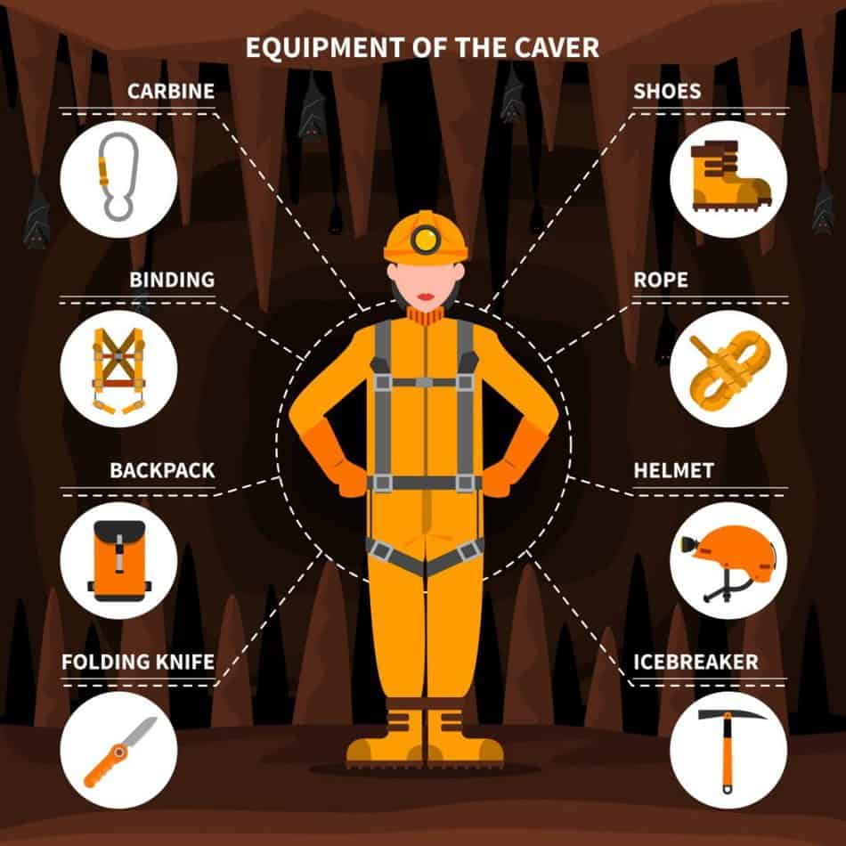
When you’re ready to get started caving, be sure to read my Beginners Guide and check out my recommended gear section.